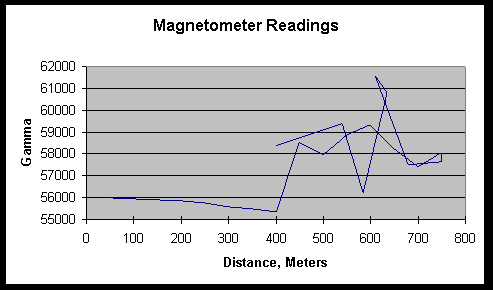

Graph 2: Sithylemenkat Lake magnetometer readings from a point 250 meters south of the central north shore to the NNE (see graph 1 for an approximate direction of travel). The return line was from a point to the NNE
The GPS readings were not accurate enough to be useful (see graph 1), so the distance is estimated and may not be very accurate. On the trip out measurements were taken approximately every 50 meters. The return leg, which started farther to the east of the final point of the outward trip, angled in so the final point was the same as point 8 of the outward trip. Readings were taken approximately every 70 meters, with the exception of the point s on either side of the peak (see text).
The 400 meter mark readings should have been the same; since they are not we can assume this is our minimum accuracy. With this kind of variation in the data we would be hard pressed to draw very solid conclusions from our data.
The current copyright laws protect this page, even though not specifically copyrighted.
However if you want to use portions of it feel free to do so, though I would appreciate it if you would acknowledge my authorship.
First written Spring 1999